| Distance: | No data |
| Minimum elevation: | No data |
| Maximum elevation: | No data |
| Elevation gain (~): | No data |
| Elevation loss (~): | No data |
| Duration: | No data |
A journey through time directly behind our vineyards
Looking out over the sun-drenched vineyards from Tramin, you’ll see the shining Corno Bianco near Aldein on the horizon – a mountain that appears innocuous at first glance, but actually holds a whole history. Beneath it lie spectacular layers of earth, carved out by the Bletterbach stream over millennia.
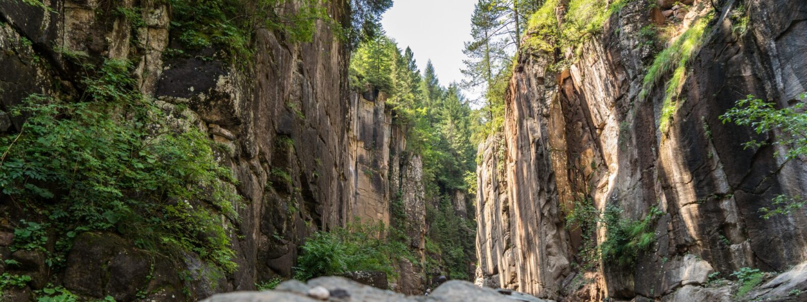
The Bletterbach Canyon – often referred to as the “Grand Canyon of South Tyrol” – winds its way roughly 8 km deep into the rock, reaching a depth of up to 400 m, and vividly demonstrates how mighty and yet delicate our mountain range is. This geological treasure trove, located right next to Tramin, allows you to walk through no less than 40 million years of Earth’s history on a single hike.
Since the last Ice Age – approximately 15,000 to 18,000 years ago – the Bletterbach stream has carved its way into the ancient Permian-Triassic rock. Its up to 400-meter-high rock faces impressively reveal the colorful rock layers: from the Bolzano quartz porphyry to the Val Gardena sandstone to the bright dolomite crown of the Weisshorn.
All along the GEO educational trail, you’ll encounter fossilized relics: petrified plants, shell prints, and even reptile footprints – silent testimonies from long-gone seas and swampy worlds.
The Bletterbach Canyon is part of the UNESCO Dolomites World Heritage Site – the eighth system within this unique protected area – and vividly illustrates the geological history of the Dolomites.
The Aldino Visitor Center at the canyon entrance serves as an educational introduction – with interactive exhibits, modern information panels, and a multimedia experience that makes the GEO trail accessible to young and curious explorers. The nearby GEOMuseum Radein exhibits geological finds, rock collections, and original dinosaur tracks – a highlight especially for families and school groups.
From May to October, we offer guided adventure tours through the Rio delle Foglie daily at 10:30 a.m. – approximately 3.5 hours of learning, exploration, and moments of wonder. Themed hikes such as “Bletterbach for Kids” or personalized GEO excursions are also available.
Not far from Aldino rises the striking Corno Bianco (2,316 m) – a worthwhile hiking destination accessible from the canyon. Its summit, formed from the same rock as the uppermost layer of the canyon, offers breathtaking views of the Bletterbach Valley.
The Bletterbach Gorge is open from May 1 to October 31. During this time, visitors can visit the gorge, the visitor center in Aldein, and the GEOMuseum in Radein daily from 9:30 a.m. to 5:00 p.m. Please note that the gorge is closed in winter due to the increased risk of rockfall.
From Tramin, you can reach the Bletterbach Gorge in about 40 minutes by car. The route leads via Auer and Montagna to Aldein, where the visitor center is located. There is a large, paid parking lot. The hike through the gorge begins from this starting point. The road to the visitor center is well-maintained.
Geoparc Bletterbach can be explored independently or on guided tours. Admission includes access to the visitor center, the GEOMuseum in Radein, and a rental helmet. The “Zirmersteig” trail takes you to the top of the Aldeiner Weisshorn, where impressive views deep into the gorge and across the South Tyrolean mountain panorama, including the Latemar and Sciliar-Catinaccio World Heritage sites, await. The return journey leads either back to the visitor center or along a beautiful circular trail along the north side of the Weisshorn.
Entry into the Bletterbach Gorge is subject to a fee. All information on prices and guided tours can be found here.
The hike through the gorge is easily manageable for experienced hikers in good weather, but sturdy footwear is essential. During rain, thunderstorms, or cold temperatures, the gorge should not be entered due to the increased risk of rockfall. Please check the weather forecast in advance to ensure safety. Wearing a helmet is recommended for a safe tour. Dogs are permitted, but must be kept on a leash. There are steep iron steps along the trail, which pose a high risk of injury to dogs.
| Distance: | No data |
| Minimum elevation: | No data |
| Maximum elevation: | No data |
| Elevation gain (~): | No data |
| Elevation loss (~): | No data |
| Duration: | No data |


Accommodation in Tramin
Ads
Available accommodation
 Urbanhof. Quiet place with pool.
 Hotel Pernhof. Suites & Apartments, restaurant, sauna
 Rebenheim. New rooms and new breakfast room
 Goldene Traube, Panorama & Überbacherhof. B&B, apart., re...
 Vineus. New! Appartments, suites and rooms
 Gartenheim. Quiet, central, breakfast under vines, pool & gar...